
Quito
Overview
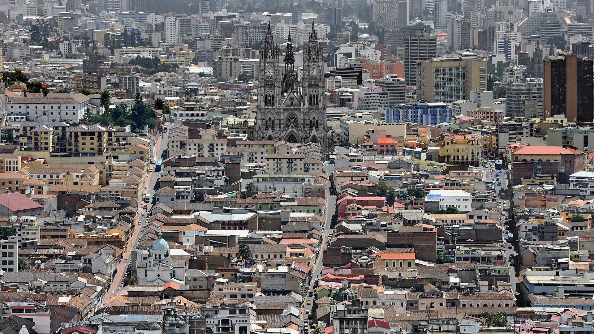
Quito runs north to south along a high valley under the volcano Pichincha, which makes the city unusually long and narrow. Its Centro Histórico was among the first sites inscribed on the UNESCO World Heritage List, in 1978, and remains one of the largest and least altered colonial centres on the continent.
North of the old city, the modern districts of La Mariscal and La Carolina hold the hotels, offices and parks. The equator itself passes just north of the city, which is where the country's name comes from.
Why Visit
Quito offers a colonial core of exceptional quality (churches heavy with gilded Baroque, monastery cloisters, painted domes) in a compact, walkable area, with Andean landscape immediately outside it.
It is also the natural starting point for Ecuador: the Avenue of the Volcanoes to the south, the cloud forest at Mindo to the west, the Amazon to the east, and flights to the Galápagos.
Best Things to Do
- La Compañía de Jesús. A Jesuit church whose interior is almost entirely covered in gold leaf, and the single most striking building in the old city.
- Basílica del Voto Nacional. A neo-Gothic basilica with gargoyles modelled on Ecuadorian animals; the towers can be climbed by ladder and walkway for a view over the city.
- Plaza Grande and the cathedral. The main square, with the presidential palace, the archbishop's palace and the cathedral around it.
- San Francisco. The oldest and largest colonial complex in the city, with a monastery, museum and a broad sloping plaza.
- TelefériQo. A cable car up the flank of Pichincha to around 4,000 metres, with trails to the Rucu Pichincha summit for the acclimatised.
- El Panecillo. The hill with the winged Virgin above the old town; take a taxi rather than walking up, as the approach streets are not safe on foot.
- La Ronda. A restored colonial lane of workshops, cafés and music in the evenings.
Destinations & Attractions

Map
Map data © OpenStreetMap contributors
Best Time to Visit
Quito sits on the equator at altitude, so temperature varies more between day and night than between seasons: mild days and cold evenings all year.
June to September is the drier season and generally the most reliable for clear mountain views.
October to May is wetter, with rain often arriving in the afternoon rather than lasting all day. December brings the Fiestas de Quito, which fill the city.
The equatorial sun is intense at this altitude regardless of temperature; burn happens quickly even on cool days.
Where to Stay
Centro Histórico puts you among the churches and plazas, which are beautiful by day and very quiet at night. Choose a hotel on a main, well-lit street.
La Floresta is the best balance for most visitors: residential, safe, with independent cafés, restaurants and a cinema, and a short ride to the old town.
La Mariscal was the traditional traveller district; it has declined and has a poor safety reputation at night.
González Suárez and La Carolina are modern, comfortable and convenient for the airport road and the park.
Neighborhoods
Centro Histórico: the UNESCO-listed colonial core, with the plazas, churches and monasteries.
La Ronda: a restored lane at the southern edge of the old town, lively in the evenings.
La Mariscal: the older traveller and nightlife quarter, now mixed and best avoided late at night.
La Floresta: bohemian and residential, with the best independent cafés and restaurants.
La Carolina: the large northern park, surrounded by shopping and business districts.
Cumbayá: a warmer valley suburb east of the city, on the way to the airport.
Transportation & Airports
Ride-hailing apps and radio taxis are the standard way to move, and are inexpensive. Street taxis should be avoided at night; use apps or have a hotel call one.
The Metro de Quito runs the length of the valley and is clean, cheap and useful, connecting the old town with the northern districts. The trolley and bus corridors also run north–south and are crowded.
Mariscal Sucre Airport is at Tababela, well outside the city, and the transfer takes around an hour; allow for traffic. Long-distance buses leave from the Quitumbe and Carcelén terminals.
Food
Highland Ecuadorian food is hearty. Locro de papa, a potato and cheese soup with avocado, is the dish to start with. Fritada, hornado (slow-roasted pork) and llapingachos, potato cakes with peanut sauce, are the staples.
Ceviche in Ecuador is served differently from Peru, often with a looser, more soupy marinade and accompanied by popcorn or plantain chips.
Encebollado, a fish and cassava soup, is the national hangover cure. The set lunch, or almuerzo, is the best value meal of the day, and the markets (San Francisco, Santa Clara, Iñaquito) are where to find it.
Day Trips
Mitad del Mundo and the nearby Intiñan site mark the equator north of the city; the monument's line is slightly off the true equator, which the neighbouring site makes much of.
Otavalo, about two hours north, has one of the largest Indigenous markets in South America, at its fullest on Saturdays, with Cotacachi and Cuicocha crater lake nearby.
Cotopaxi National Park, to the south, surrounds one of the world's highest active volcanoes; access depends on volcanic activity and is sometimes restricted.
Mindo, in the cloud forest to the west, is a change of climate and the best birdwatching within easy reach. Papallacta, east, has hot springs at altitude.
Budget
Ecuador uses the US dollar and Quito is inexpensive. The set lunch, market food and local transport all cost very little, and ride-hailing across the city is cheap.
Church and museum entries are modest. The larger costs are excursions (Cotopaxi, Otavalo, Mindo) and, separately, the Galápagos, which is a major expense involving flights and park fees and is not comparable to mainland prices.
Travel Tips
Take altitude seriously. At 2,850 metres, allow a day or two before strenuous activity, drink water and go easy on alcohol at first.
Sun protection is essential. Equatorial UV at this altitude is extreme even when the air is cool.
Use ride-hailing apps rather than hailing taxis, especially after dark, and avoid walking in the old town and La Mariscal late at night.
Carry small bills. US dollars are the currency and change for large notes is often unavailable.
Check volcanic activity advisories before planning Cotopaxi; access is periodically restricted.
Frequently Asked Questions
How many days do I need in Quito
Two days cover the historic centre and the TelefériQo. A third allows Otavalo or Mindo, and most visitors use the city as a base for longer.
How bad is the altitude
Most people feel some breathlessness for a day or two. Serious altitude sickness is uncommon at 2,850 metres but not impossible; take the first day slowly.
Is Quito safe
The main concern is opportunistic theft and robbery, particularly at night and in La Mariscal and around El Panecillo. Use apps for transport and check current official advice before travelling.
Can I visit the equator
Yes, at Mitad del Mundo north of the city, about an hour away, usually combined with the adjacent Intiñan site.
Plan your trip to Quito
Free tools for flight times, time differences, budget, money and plugs.
- Flight Duration CalculatorWork out real flight time across time zones.
- Time Zone ConverterFind the time in another city instantly.
- Trip Budget CalculatorEstimate your total trip cost, item by item.
- Currency ConverterConvert prices between currencies at indicative rates.
- Travel Plug & Voltage CheckerCheck if you need a plug adapter or voltage converter.
- Jet Lag CalculatorEstimate how many days you need to beat jet lag.
